Thesaurus d’Épigraphie Islamique Updates

Aside

The Thesaurus d’Épigraphie Islamique was recently updated and now includes

  • Issue No. 10: Inscriptions from South-East Asia (Burma, Brunei, Cambodia, China, Indonesia, Malaysia, Mongolia, Philippines, Thailand, Vietnam)

It is now that much easier to find something like the Arabic stela excavated at Phnom Bakeng, probably carved by a local craftsman unfamiliar with the Arabic alphabet!

Arabic Stela - Phnom Bakheng

Access to the searchable database is free once you’ve created an account. The new material completes content already in the database:

  • No. 1: Morocco, Algeria, Tunisia and Libya
  • No. 2: Arabian Peninsula (Saudi Arabia, Yemen, Oman, Bahrain)
  • No. 3: Central Asia (Uzbekistan, Kazakhstan, Kyrgyzstan, Tajikistan, and Turkmenistan)
  • Nos. 4 and 5: Egypt
  • No. 6: Indian world (Pakistan, India, Bangladesh, Sri Lanka, Maldives)
  • Nos. 7-9: Sub-Saharan Africa, Iraq, Western Europe (Spain, Portugal, Italy, Malta, France)

A Converted Temple in Cappadocia?

One of the more interesting and less well-understood sites that we visited was a Byzantine church complex that appears to have been a renovation to an earlier, polytheistic temple. As I understand it, the bases of the four piers in the church are uncharacteristic of the Byzantine cave churches.

The upper part of the complex has eroded and collapsed, leaving much of it exposed. There are still several adjoining cave-rooms, but the exposed portion makes for a beautiful photosynth.

Tiberias

Featured

This summer I was excavating at Tiberias. The New Tiberias Excavation Project, led by Dr. Katia Cytryn-Silverman of the Hebrew University of Jerusalem, is intended to clarify the structure of the mosque built in the center of the city, as well as to determine its relationships to nearby monumental structures, both religious and secular.

Tiberias, located on the south-western coast of the Sea of Galilee (more commonly known here as the Kinneret), was founded in 20 CE by Herod Antipas, the son of Herod the Great, and has been continuously occupied since, although occupation appears to have shifted to the northwest over time. Judaism, Christianity, and Islam all left their mark on the urban center. After the rabbinical court known as the Sanhedrin was forced to flee Jerusalem, they eventually settled in Tiberias in the late second century. Ephiphanius of Salamis mentions the city in his Panarion (check it out for a delightful account of amorous magic in the pagan baths), al-Muqqadasi describes it in his geography, and Nasir-i Khusrou also briefly mentions the city in the Safarnama. During the 10th century the Aleppo codex was compiled there, and with the arrival of the crusaders it became the capital of the Principality of Galilee within the Kingdom of Jerusalem before it was reconquered by Saladin in 1187. In short, it was a pretty happening place. Now it’s pretty touristy, catering to Christian pilgrims looking for a base from which to visit the numerous biblical sites surrounding the lake and Israelis looking for some fun in the sun and a nice soak in the hot springs of Hamat Tiberias.

Highlights of the dig (apart from the excavation itself) included a trip to the Umayyad estate Khirbet al-Minya, a hike up to the anchor church on Mt. Berenice with its amazing view of the lake, and squeezing into some recently-excavated chalcolithic dolmens at Rujm el-Hiri.

Tafila-Busayra: Learning from the Random Squares

I was hoping to learn more from the random square data of the Tafila-Busayra survey than I actually have. The material culture provides little more than a verification of the general trends in the number of sites by period. The geographic distribution of the random squares across the three “zones” (gorges, plateau, and desert) that MacDonald distinguishes, however, might add a qualitative nuance to the purely quantitative analysis of the major sites I’ve been working on.

From Burton MacDonald, Tafila-Busayra Archaeological Survey, Phase 2 Report

From Burton MacDonald, Tafila-Busayra Archaeological Survey, Phase 2 Report

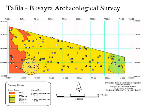
11 of the random squares were located in the gorge region, 70 in the central plateau, and 6 in the desert region to the east. Of the 11 located in the gorges, only 6 had a gentle enough slope to be properly surveyed. When you break down the random squares by geography and which periods of material culture are represented, it’s clear that most of the random squares containing material culture for any period were located on the plateau:

This, however, is a bit deceptive considering how many of the random squares are located on the plateau in the first place. Looking at the percent of the random squares within a zone that contain material culture for each period allows for a slightly less skewed comparison, but it’s still a distortion:

Byzantine material culture occupies the largest percentage of squares within all three of the regions. Perhaps more interesting is the way the distribution shifts in the Early-Medieval through Early Modern periods. Both the very percentage of Early Medieval presence in the random squares on the plateau and the fact this is the only period for which the random squares with material culture on the plateau don’t significantly outnumber those in the other zones would suggest that something strange is going on. My first impulse is to attribute this to the difficulty of distinguishing Byzantine and Early Medieval potsherds, which MacDonald implicitly acknowledges in his periodization. The exclusive presence of Late Medieval material culture on the plateau, on the other hand, makes more sense.

I’ve been reluctant to map the random square data, but I think maps would allow a comparison of the presence of material culture within random squares across periods. This chart prompts two related questions:

  1. Where does one see “continuity” rather than “change”?
  2. Is there continuity within zones, and for which cultural transitions?.